Quick Links

")
 Baggage Claim")
")
")
 Lost and Found")
")
 Map")
")
")
")
")
")
 TSA Security Wait Times")

Up to 50% Off Your Next Hotel Stay
Use promo code: AAHD | Call-Only Deal: +1-866-302-0055
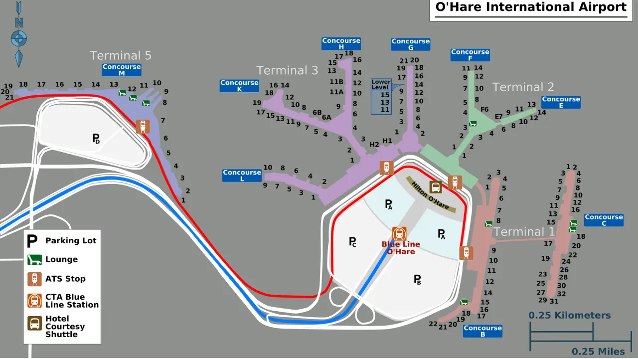
Chicago O’hare International Airport has a layout with 5 terminals. All these terminals are connected to the Airport Transit System which helps passengers with seamless travel. The map of Chicago O’Hare International Airport (ORD) helps passengers navigate the terminal layout, extensive facilities, and many transportation options.
This guide covers the map of O’Hare Airport, helping passengers with key locations, and amenities that minimize transition time for a hassle-free travel experience.
Map of Chicago O’Hare International Airport (ORD)
Below is the interactive map of the ORD Airport that helps passengers easily navigate their respective terminals:
Explore Chicago O’Hare International Airport (ORD) with Map
Navigating through the O’Hare Airport map involves accessing the Airport Transit System or using the entry and exit points for moving within the terminals. This also includes using public transportation options like taxis and rental cars that can be located through the aforementioned airport map.
Below is a detailed breakdown of all the locations at ORD Airport and how passengers can identify them using the map:
Entrances and Access Points
O’Hare Airport features dedicated entry points for passengers, including main terminals, TSA security checkpoints, and baggage claim exits. In addition, there are designated areas for ride-shares, taxis, and public transportation.
An interactive map of O’Hare Airport helps passengers locate these key points, helping passengers save their time at the airport:
- Main Entrances: The main entry to O’Hare is via I-190, offering access to all terminals. If you look at the ORD Terminal map. The Upper Level at each terminal is meant for departures, while the Lower Level is for arrivals.
- Drop-Off Areas: There are designated drop-off areas at the curb front of any terminal. In addition, the drop-off points are available at Mannheim Road and Zemke Boulevard, which are on the Northeast.
- Taxi Stands: Taxi stands are located on the lower level curb front, outside of baggage claim, at each terminal.
- Rideshare Pickup Zones: ORD Terminal 2 has a dedicated rideshare pickup on the upper-level departure area. Passengers arriving from all other terminals must take the Airport Transit System (ATS) to Terminal 2.
- Bus Stops: Arriving and departing passengers must proceed towards the Multi-Modal Facility (MMF) at 10255 W. Zemke Boulevard. It is accessible via the Airport Transit System (ATS) from any terminal.
Check-in and Security Areas
The check-in and security areas are located at the departure level of each terminal at ORD Airport. You can use the ORD terminal map to identify the exact coordinates. In addition, the TSA security checkpoints are also marked on the map and are accessible past the check-in counter.
In addition, there are expanded security lanes at all terminals to help passengers reduce the security wait times at ORD International Airport:
- Check-in Counters: Available in Terminals 1, 2, 3, and 5, with major airlines operating check-in counters.
- Self-Service Kiosks: Located in the departure lobbies of each terminal. To get the exact location of the self-service check-in kiosk, refer to the ORD Terminal map.
- TSA Security Checkpoints: TSA security checkpoints are located in Concourse B at the lower level of Terminal 1. At Terminal 2, it is located at the Exit Lane Checkpoint 4A. For passengers departing from ORD Terminal 3, go to the exit lane Checkpoint 9. For Terminal 5, take the Concourse M Exit to proceed to the TSA security checkpoint.
Shops and Services
Shops and Services are located pre-security and post-security at all terminals at ORD Airport. You can find them using the O’hare Airport Map above:
- Duty-Free Stores: There are 2 Duty-free outlets at the ORD Airport – Terminal 2 and Terminal 3. At Terminal 3, it is located near Gate K5, and at Terminal 2 is near Gate F5.
- Books and news: ORD Terminal 1, Terminal 2, and Terminal 3 have Barbara’s Bookstore. Terminal 3 also has CNN Newsstand Chicago at Gate H5. There are over 30 Hudson Newsstands that are located across all terminals.
- Spa Services: Terminal Gateway Spa is located at Terminal 1, Concourse B, near Gate B12, and Terminal 3, Concourse H, near Gate H1.
- Currency Exchange: Seaway Bank offers currency exchange services at Terminal 1 near Gate B10 and C18, Terminal 2 near F1 Gate, Terminal 3 near Gate K10, and Terminal 5 near Upper Level.
- Electronics: InMotion electronics stores are located in Terminals 1, 2, 3, and 5.
- Accessories & Gifts: Stores like Hoypoloi, An Uncommon Gallery, Brighton Collectibles, Duty-Free Stores, and InMotion offer gifts and accessories. These stores are located in Terminals 1, 3, and 5. You can navigate these stores and reach their exact location via the O’Hare Airport Chicago map.
- Vending Machines: AG1 Has a vending machine at Terminal 3 near Gate H1. There is a vending machine dedicated to the baby essentials and is located at each terminal. The other vending machines include CVS Vending machine, Chicago Essentials, IStore, Kylie Cosmetics, LEGO, and PollyPocket.
Check out our latest guide on all shopping options available at Chicago ORD Airport.
Food and Beverage Options
O’Hare Airport offers a wide range of food and beverage options, including quick-service restaurants, cafés, fine-dining establishments, and grab-and-go kiosks. The map of O’Hare Airport helps travelers easily locate dining spots to enjoy pre-flight meals:
- Breakfast: Passengers at Terminal 1 can explore America’s Dog and Auntie Anne’s. Terminal 3 has B-Smooth, BJ Gourmet Market, Burrito Beach, and Chilli’s for a breakfast option. Passengers looking for breakfast from QSRs can access Burger King and Dunkin’ Donuts at ORD Terminal 5.
- Full service: Brioche Doree outlets are available at Terminals 1, 2, and 3, and are ideal for fine dining. Alternatively, Sky Bridge Bar & Grill and Stanley’s BlackHawks Kitchen & Tap at Terminal 2 are also some good options.
- Grab and go: The vending machine by Canteen Healthy Snacks offers plenty of on-the-go options. These are available at Terminals 1, 2, 3, and 5. Other grab-and-go options include Carry Out Carry On at Terminal 2, Chi Life Market at Terminal 1, and Farm2Air Market at Terminal 5. You can navigate these options through the O’Hare Airport map.
- Local flavors: To indulge in local cuisine and flavors, you can visit Home Run Inn Pizza at Terminal 2 and Pronto Sandwiches at Terminal 1. Publican Quality Bread and Six Points Market are located at Terminal 5.
- Bar: Passengers looking for gastropubs can visit Beaudevin Wine Bar and Berghoff Cafe at Terminal 1. Bubbles Wine Bar, Facades Bar, and Goose Island Beer Company are located at Terminal 3. There are other bar options available throughout the terminal and can be accessible via the map of O’Hare Airport.
- Kids meals: The Hampton Social at Terminal 5 near Gate M7 is a perfect dining option for families and kids.
- Cafés and Coffee Shops: Starbucks and Dunkin’ Donuts are available at all terminals.
Read more on all restaurant options available at Chicago O’Hare Airport (ORD).
Passenger Comfort and Convenience
O’Hare Airport enhances passenger comfort with amenities such as nursing rooms, currency exchange, and other family-friendly facilities. An interactive ORD Terminal Map helps passengers navigate these services:
- ATMs: ATMs are located in each terminal near the pre-security and post-security areas. You can locate the ATMs using the O’Hare Airport map.
- Body chargers: Passengers can take a quick and relaxing therapy at the Body chargers kiosks located at multiple locations in Terminal 1 and Terminal 3.
- Mamava lactation pods: nursing mothers can access the Mamava location pods at terminals 1, 2, and 3.
- Baggage Storage: The airport does not have any luggage storage facilities.
- Charging Stations: The airport has ‘Power Stations’ which are seated workstations with USB outlets and AC that are located in various concourses near the terminals. Terminal 1 has stations in Concourses B and Concourse C. In Terminal 2, there are stations in concourses E, F, and L. In Terminal 3, there are stations in Concourse G, H, K, and L.
- Family Restrooms: Gender Toilets with baby-changing tables are located in all terminals and the Multi-Modal facility.
- Pet Relief Areas: If you look at the ORD gate map, you can find three outdoor areas near the lower-level curb. These areas are located opposite Terminals 1, 2, and 5. There’s an indoor pet relief area in Terminal 3’s Rotunda.
Transportation and Parking Options
O’Hare Airport provides various transportation and parking options, including the CTA Blue Line, airport shuttles, rental cars, taxis, and rideshares. The ORD Airport Map assists passengers in locating transportation and parking hubs at the airport.
Check out our latest guide on all transportation options available at Chicago ORD Airport.
Click here to get access to all parking options at Chicago O’Hare Airport.
Hotels
The ORD Airport map highlights all the hotels that are available within the proximity of the airport. Certain hotels are located within 1-2 miles of the airport, while other airports are 5-10 minutes drive from the airport.
Look for the map above that displays all the hotels at ORD Airport thus helping passengers make the best choice as per their travel needs.
Find out all the accommodations and hotels available near Chicago O’Hare Airport (ORD).
Whether you’re traveling for the first time or returning to ORD Airport after a long hiatus, the map is your most important resource. It helps you track key locations for a smooth departure and arrival. Also, passengers who need to visit an exotic shopping or dining place can access the map displayed above for an enhanced airport experience.
FAQs
You can find an official map of O’Hare International Airport (ORD) mentioned above or you can visit the Fly Chicago portal, i.e., the official website of the Chicago Airport.
O’Hare Airport has an easy-to-use terminal map that shows connections between Terminals 1, 2, 3, and 5. Through the map, you can also locate ATS (Airport Transit System) which helps passengers for inter-terminal transits and parking areas.
Gate maps for all terminals at ORD are mentioned above. You can also explore digital directories that can be accessible via the Welcome Centre at all terminals. This will help passengers locate the departure gate, arrival gate, security checkpoints, and other key locations at the ORD airport.
Yes, O’Hare Airport provides a food and dining map that lists all restaurants and food courts in each terminal.
Baggage claim areas at O’Hare are located on the lower levels of each terminal. The Chicago O’Hare baggage claim map is displayed near the arrivals area for easy navigation.